Thursday, May 31, 2012

still sunny in our land

still sunny by brexians
still sunny, a photo by brexians on Flickr.
still sunny in our land #Pelasgia central #Greece #travel #ttot #travelling2GR #visitGreece
PHOTO via: brexians ... http://www.flickr.com/photos/brexians/6515549373/

Monday, May 28, 2012

Ios island ... church @ daylight

a superb #photo from #Ios #Cyclades #Greece #travel #ttot #travelling2GR #visitGReece
PHOTO via: Christos Loufopoulos http://www.flickr.com/photos/ophilos/7278508502/


Ios (GreekΊος, locally Νιός - Nios) is a Greek island in the Cyclades group in the Aegean Sea. Ios is a hilly island with cliffs down to the sea on most sides, situated halfway betweenNaxos and Santorini. It is about 18 km (11 mi) long and 10 km (6 mi) wide, with an area of about 109 km² (42 mi²). Population was 1,838 in 2001 (down from 3,500 in the 19th century). Ios is part of the Thira regional unit. Ios was the setting for the movie Ginger and Cinnamon (Dillo con parole mie). Also, scenes from the film Big Blue (Le Grand Bleu) were shot in Manganari.


The Port of Ios is at the head of the Ormos harbor in the northwest. From there the bus or a 15-minute walk up the steep donkey path takes you to the village, known as Chora. Chora is a white and very picturesque cycladic village, full of stairs and narrow paths, that makes it inaccessible for cars of any kind. Today, the main path through this village is completely taken over by tourism in terms of restaurants, boutiques, bars and discothèques. Apart from the port and the village of Chora, Ios has only a few small settlements, just a group of spread out houses in the background of major beaches (Theodoti, Kalamos, Maganari). Since the 1990s, the island mayor Pousseos has worked on Ios' development towards attracting different types of tourists. With the help of European Community funds some roads have been built, all of them paved, and a scenic amphitheater has been created by the German architect Peter Haupt (who died in 2003) at the top of the village hill. Unfortunately, cultural events rarely take place up there.


Excavations on Skarkos hill unearthed a prehistoric settlement, proving that Ios has been inhabited since the early Cycladic period. The architecture at Skarkos is preserved in places up to a height of almost three meters, with most of the buildings evidently having two storeys, stone-paved floors and a sewage system. Numerous well-preserved pottery, tools and utensils made of metal, stone and bone were also discovered. Unfortunately, the Skarkos site remains largely unpublished. In 2008, Ios was among six European locations (out of 109 candidates) awarded the European Union Cultural Heritage prize for its exceptional conservation efforts at the archaeological site of Skarkos.
During later times, Ios made rather few marks in history. According to ancient tradition, Homer's mother was from Ios, and he himself was buried there - and indeed the locals will show visitors the site of the ancient town of Plakotos at the northernmost end of the island, where the rocky entrance to a tomb may be seen. There is no physical evidence connecting this with Homer however. There are signs of Mycenaean settlement. The north end of Ios has a ruined Venetian castle from the 15th century. The island is said to have 365 churches and chapels, like the days of the year.
Ios attracts a large number of young tourists, many of whom used to sleep on their sleeping bags during the 1970s on the popular beach of Mylopotas after partying through the night. Today Mylopotas beach has been developed to an equivalent mass package tourism resort like Platys Gialos and Paradise Beach of Mykonos.
From Wikipedia, the free encyclopedia


Tuesday, May 22, 2012

Lalaria beach Skiathos

Lalareality by vainas
Lalareality, a photo by vainas on Flickr.
Lalaria Beach #Skiathos island #Greece #travel #ttot #travelling2GR #visitGReece
PHOTO via: Konstantinos Vainas http://www.flickr.com/photos/vainas/1142244759/


Skiathos (GreekΣκιάθοςpronounced [sciˈaθos]; Latin forms: Sciathos and Sciathus) is a small Greek island in the northwest Aegean Sea. Skiathos is the westernmost island in the Northern Sporades group, east of the Pelion peninsula in Magnesia on the mainland, and west of the island of Skopelos.

In Ancient times, the island played a minor role during the Persian Wars. In 480 BC, the fleet of the Persian King Xerxes was hit by a storm and was badly damaged on the rocks of the Skiathos coast. Following this the Greek fleet blockaded the adjacent seas to prevent naval invasion and provisions for the enemy of 300 Spartans who stood heroically at Thermopylaepass. The Persian fleet was defeated there at Artemisium and finally destroyed at the Battle of Salamis a year later. Skiathos remained in the Delian League until it lost its independence. The city was destroyed by Philip V of Macedon in 200 BC.
In 1207 the Gyzi brothers captured the island and built the Bourtzi, a small Venetian-styled fortress similar to the Bourtzi in Nafplio, on an islet just out of Skiathos Town, to protect the capital from the pirates. But the Bourtzi was ineffective in protecting the population and in the mid-14th century the inhabitants moved the capital from the ancient site that lay where modern Skiathos Town is to Kastro (the Greek word for castle), located on a high rock, overlooking a steep cliff above the sea at the northernmost part of the island.
In 1704 monks from Athos built the Evangelistria monastery which played a part on the Greek War of Independence as a hide-out for Greek rebels. The first flag of Greece was created and hoisted in the Evangelistria monastery in Skiathos in 1807. Several prominent military leaders (including Theodoros Kolokotronis and Andreas Miaoulis) had gathered there for consultation concerning an uprising, and they were sworn to this flag by the local bishop.
The film Mamma Mia was partially filmed on Skiathos and nearby island Skopelos. This has increased its popularity as a tourist destination since the release of the successful movie.After the War of Independence and demise of piracy in the Aegean, Kastro became less important as a strategic location. In 1830s, the island's capital was moved to the original site — where it still remains. Today, ruins of Kastro are one of tourist attractions. During the 19th century Skiathos became an important shipbuilding centre in the Aegean due to the abundance of pine forests on the island. The pine woods of the island were then almost obliterated. This was brought to a halt though, due to the emergence of steamboats. A small shipwright remains north of Skiathos Town, which still builds traditional Greek caiques.
Hollywood actor Richard Romanus moved to the island in 2001 with his wife. He has written a book about his move to the island called "Act III".


Sunday, May 13, 2012

Greek Beauties ...

Χρόνια Πολλά σ' όλες τις μανάδες του κόσμου !


#Greek Beauties ... #Chalki , #Greece
PHOTO via: Anna http://www.flickr.com/photos/9426538@N07/3904663876/

Friday, May 11, 2012

Traditional wedding bread, Thermo Nafpaktias, Greece.

Traditional #wedding bread, #gastronomy #Thermo #Aetolia-Acarnania #Greece #travel #ttot #travelling2GR #visitGReece
PHOTO via: Kakia Chatsiou http://www.flickr.com/photos/50568843@N00/2370754633/


Thermo (GreekΘέρμο, before 1915: Κεφαλόβρυσον - Kefalovryson) is a town and a municipality in Aetolia-AcarnaniaGreece. It is located in the southeastern part of the regional unit, largely between Lake Trichonida (the largest natural lake in Greece) and the southern border of Evrytania. It has a land area of 333.701 km² and a 2001 census population of 9,299 inhabitants. Its municipal seat is the town of Thérmo (pop. 1,898). Its largest other towns are Análipsis (pop. 669), Petrochóri (527), Sitarálona (390), Palaiómylos (373), Myrtéa (355), and Amvrakía (349). Thermo took its name from the ancient city Thermos, that was located near the present town.

Castle of Platamonas

Castle of Platamonas by maksid
Castle of Platamonas, a photo by maksid on Flickr.
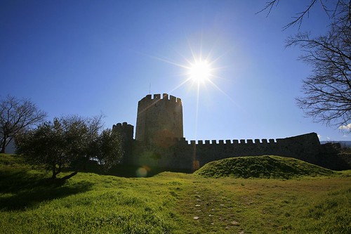
Castle of Platamonas #Pieria #Macedonia #Greece #travel #ttot #travelling2GR #visitGReece
PHOTO via: maksid http://www.flickr.com/photos/8153468@N04/3353254643/


Platamonas is a town and sea-side resort in south Pieria prefecture, Central Macedonia, Greece, near to the tallest mountain in Greece, the famous Mount Olympus.
Platamonas has a population of about 1,500 permanent inhabitants and it’s regarded as one of the most significant tourist destinations in Pieria. According to tradition its name originates either from the platan trees or from the broad sandy beaches, both of which can be found in the areas surrounding the town. Its most famous landmark is the venetian Castle of Platamon. The town is 54 km from the city of Larisa and 38 from the city of Katerini.

Thursday, May 10, 2012

Supernatural @ Methana

Methana by 9eorge
Methana, a photo by 9eorge on Flickr.
Supernatural @ #Methana #Peloponnese peninsula, #Greece #travel #ttot #travelling2GR #visitGReece
PHOTO via: George Agathos http://www.flickr.com/photos/9eorge/5032772276/


The peninsula is entirely of volcanic origin and contains over 30 volcanic eruption centers. The last volcanic eruption occurred near present-dayKameni Chora in 230 BC and a submarine volcano erupted in 1700. Famous writers such as OvidStrabo and Pausanias reported the last volcanic eruption in Methana. The peninsula is the northwesternmost of the arc of the Aegean islands of which the active volcanic areas are Methana, MilosSantorini and Nisyros. In the future, Methana (and the area of the Saronic gulf) may expect other volcanic eruptions.
The earliest known settlement (near the village of Vathy) dates from 1500–1300 BC. Many ancient sites were identified through the archaeological survey conducted in the 1980s by the University of Liverpool in association with the British School at Athens. The Acropolis Palaiokastro is located near the village of Vathy. The fortress is in Kypseli at the coast Akropolis Oga at the principal pace of Nisaki (Νησάκι, meaning little island). A Mycenaean settlement was excavated by Helene Konstolakis-Jiannopoulou in 1990 along with the chapel of Agios Konstantinos and Elenis. Selected artifacts can be visited in the museums of Poros island and in Piraeus. This site dates between 1500 and 1300 BC. In his History of the Peloponnesian WarThucydides tells of an Athenian expeditionary force under Nicias that after defeating Corinth (in 425 BC) built a wall across the isthmus to cut the Methana peninsula off from the mainland. In the Hellenistic period, the peninsula became one of the Ptolemaic bases in the Aegean when it was renamed Arsinoe. Traditionally, the population of Methana were Arvanites.